Hiking paradise between Lake Sihl and Mythen
Discover the Schwyzer Höhenweg, the Jakobsweg and the Mythen
The Mythen region is an Eldorado for adventure seekers and hikers. When there is still snow on the peaks in spring, the Alptal is already inviting for hikers.
Big and small Mythen
In the center are the two local mountains of Schwyz, the Mythen, and at their foot the Holzegg, the vantage point at the transition from the Alptal to the Schwyz valley basin. Holzegg can be reached via well-marked hiking trails and, from mid-May, via three cable cars:
from Sattel with the revolving gondola lift to the Mostelberg
from Brunni-Alpthal
from the Rotenflue mountain station, which can be reached by cable car from Rickenbach near Schwyz
For many, the mountain restaurant on the Holzegg is the end of the hike, but for others it is just the start of further adventures. A few minutes from the mountain restaurant is the entrance to a climbing garden. It offers 56 routes with a magnificent panorama.
Schwyzer Höhenweg
The Schwyz Panorama Trail connects Küssnacht am Rigi with Einsiedeln in five stages. It is characterized by the three historic mountains Rigi, Rossberg and Mythen: each of these mountain massifs has its own story to tell. Railroad history has been written on the Rigi in particular. The history of the Rossberg is closely linked to the gigantic masses of rock that slid into the valley in 1806. The history of the Mythen, on the other hand, is a geological one; they are the last remnants of a rock cover that has otherwise been completely eroded away everywhere north of the Alps. From Küssnacht, the route climbs up to the Queen of the Mountains. From the Rigi you descend to Goldau. The landslide area is still impressive today. Stage three takes you to the highest mountain in the canton of Zug, the Wildspitz. After a challenging ascent, the fourth section rewards you with a detour to the Hochstuckli. This is followed by a gentle descent to Haggenegg. The final stage bypasses the Mythen on the rear side and ends in Einsiedeln. *Getting there: with the Voralpen-Express to Küssnacht am Rigi and to the other stage starting points (some S-Bahn connections necessary), by bus to Sonogno
Via Jacobi
The fourth stage of the Way of St. James starts in Einsiedeln. From here, it heads southwest away from the monastery and - before heading out into the countryside - turns sharp right at the Altersheim stop into the southern factory area. The Via Jacobi soon crosses the Alp mountain stream, an almost 20-kilometer-long tributary of the Sihl. The route leads across some pastures and along the course of the stream past the Benedictine monastery in Au to Trachslau and on along the Alp through the Alpthal valley. The imposing local mountains of Schwyz sit enthroned at the end of the valley.
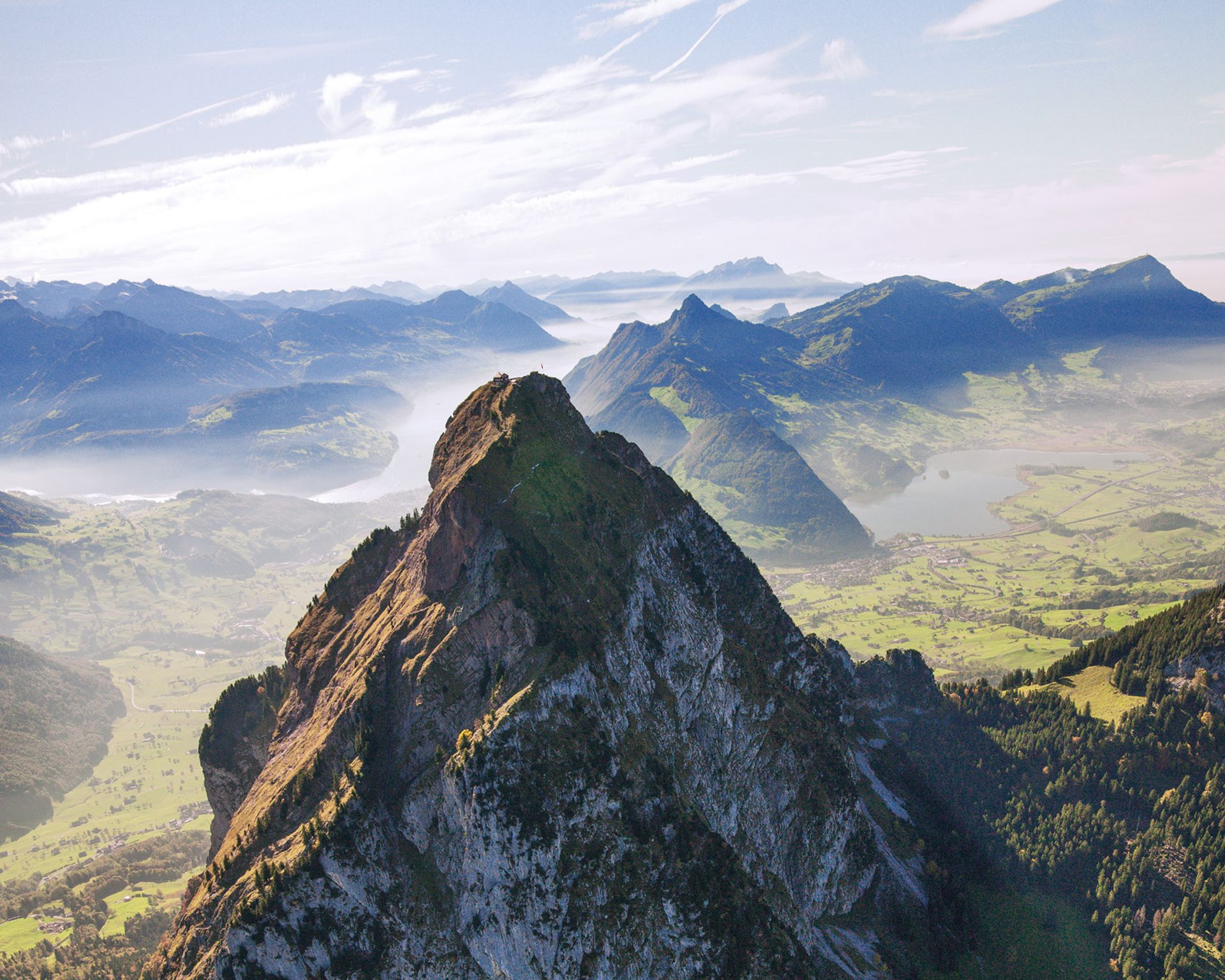
The Grosser Mythen is first in view and shortly afterwards the Kleiner Mythen. In Alpthal, after a good two and a half hours, the trail branches off to the right and crosses the Malosen bridge. A steep ascent begins here, which takes around 45 minutes and is a sweat-inducing climb. Just above Bogenfang, the efforts of the ascent are rewarded for the first time: a fantastic panorama opens up with views of the Mythen, the valley and the mountain peaks opposite.
After twelve kilometers, the trail reaches the top of the pass on the Haggenegg. It lies at 1414 meters above sea level and is the highest point of the day's stage and of the entire Way of St. James north of the Alpine ridge. Reaching this stopover calls for a celebration. The Haggenegg inn is the perfect place to do so. The view of Lake Lauerz and Lake Lucerne is fantastic, as is the view of the Rigi and the distant Alpine peaks. After the rest stop, the trail continues for the next one and a half hours, initially on a forest path and later on an asphalt road, often descending steeply to Schwyz, from where the Via Jacobi leads to Ibach. Here the hikers cross the Muota. The route continues past Ingenbohl Monastery to Brunnen, where the destination of the fourth stage is reached.